 It has been months since my last blog entry or hike, and even longer since I had time or the weather on my side for overnighting in the woods. Today’s beautiful sunshine and warm temps reminded me of a summer hike I made last year. This entry is way overdue, but perhaps this will inspire us all to get excited about the coming months of being outside and exploring our natural areas.
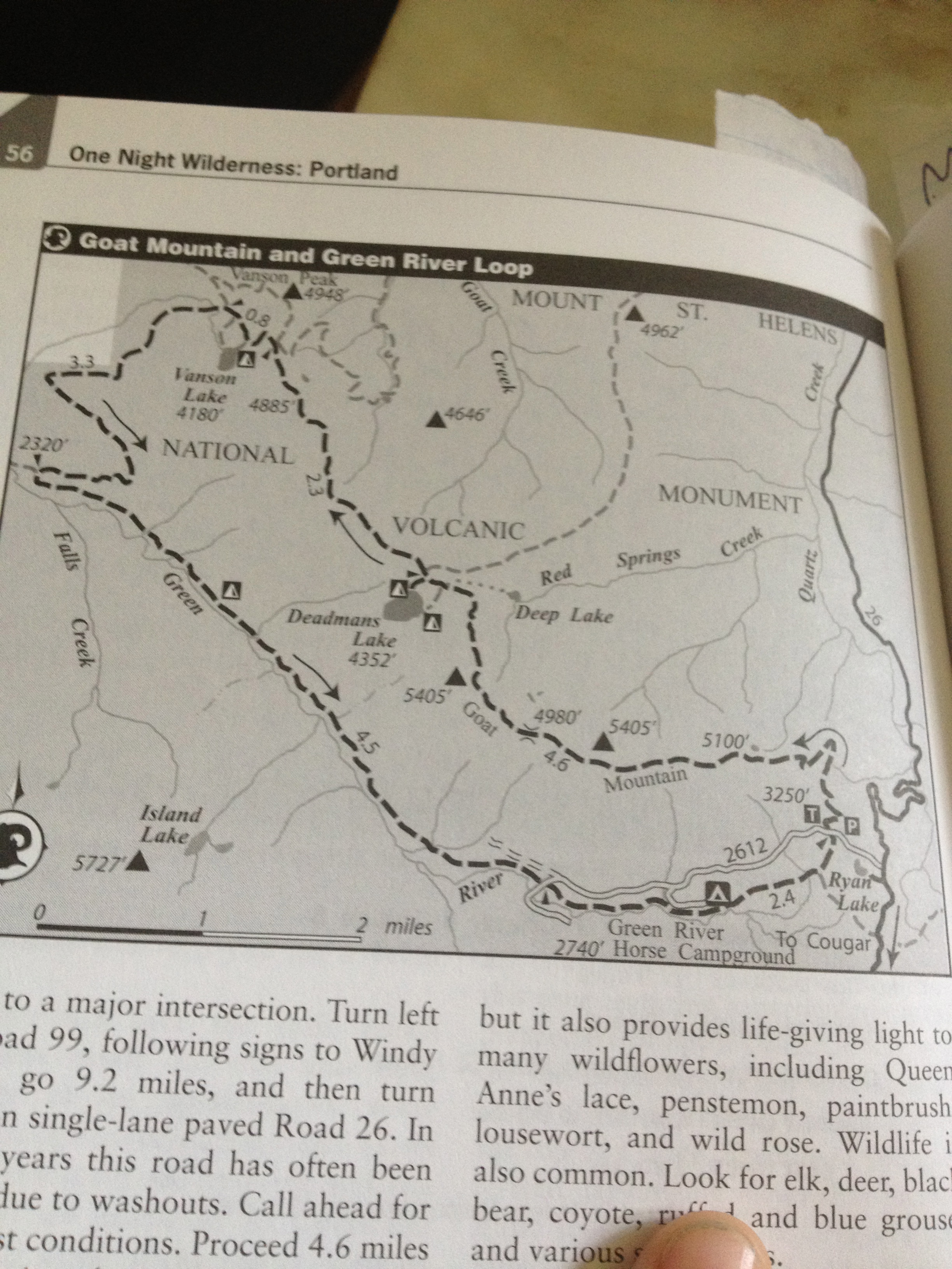
At the time of writing this it had been a while since my last hike, to find the perfect spot for this journey I scanned my copy of One Night Wilderness: Portland for ideas. I came across the Goat Mountain and Green River Loop when I looked for longer hiking distances, higher level of solitude, and greater difficulty as my three top criteria, which usually mean steep elevation gains and wondrous vistas without all the other trail hikers. This suggested route had it all, including a campsite about half the distance in on Lake Vanson.
Hike Details
Distance: 17.9 miles
Elevation Gain: 4300+ feet
Best Times: Early July… Less bugs, more flowers.
Permit: None
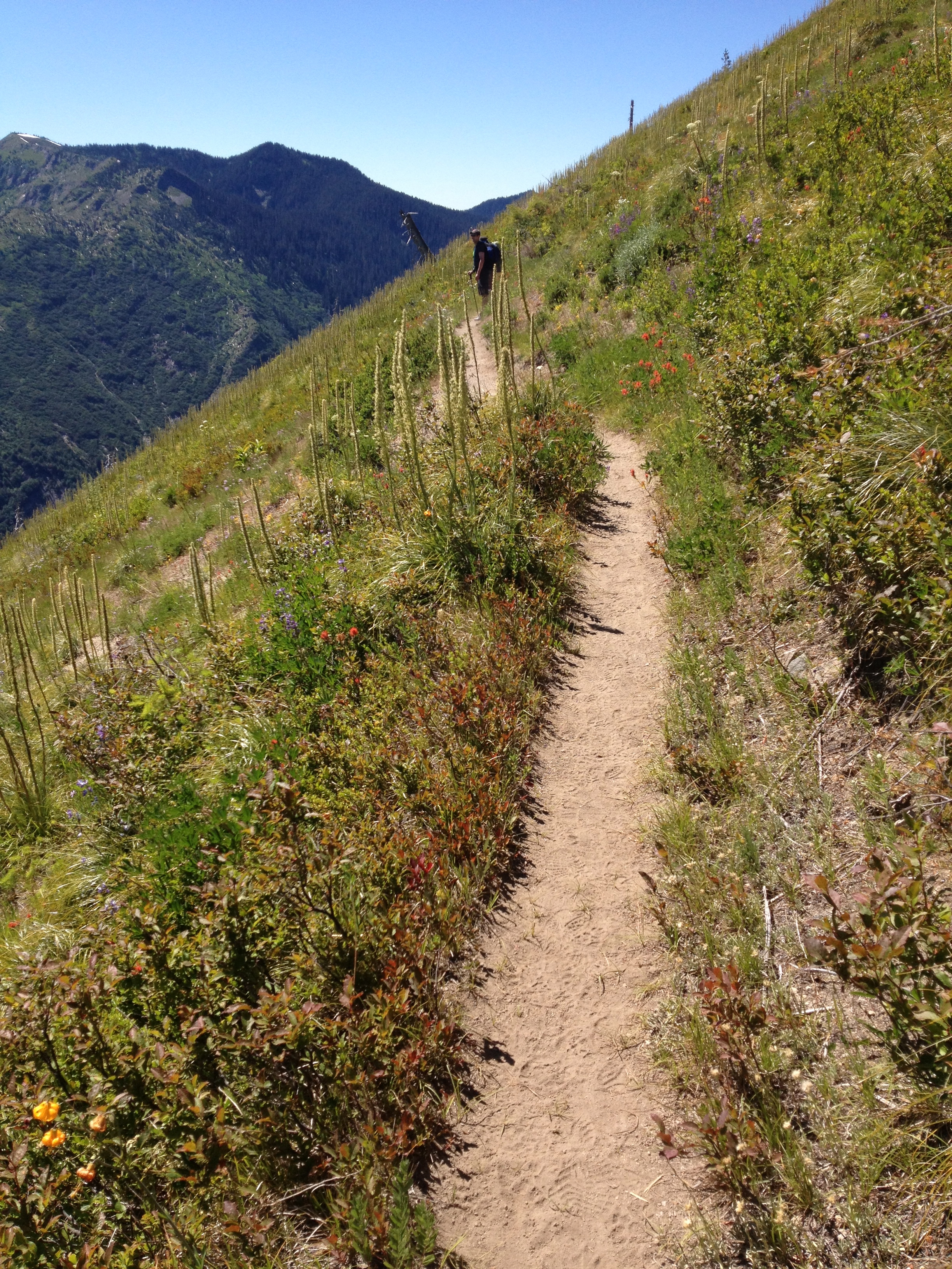
We parked near Ryan Lake, a heart-shaped lake you will see in a few photos taken from the top of the trail’s ridge. The first section of the hike was quite a bit of uphill with lots of flowers and shade. Listening to frogs bellow as we climbed and birds calling through the trees to let their neighbors know we were coming were the only sounds aside from us and the streams we crossed. As we climbed, we were harassed by several black flies, but if we set a quick pace they seemed to lag behind.
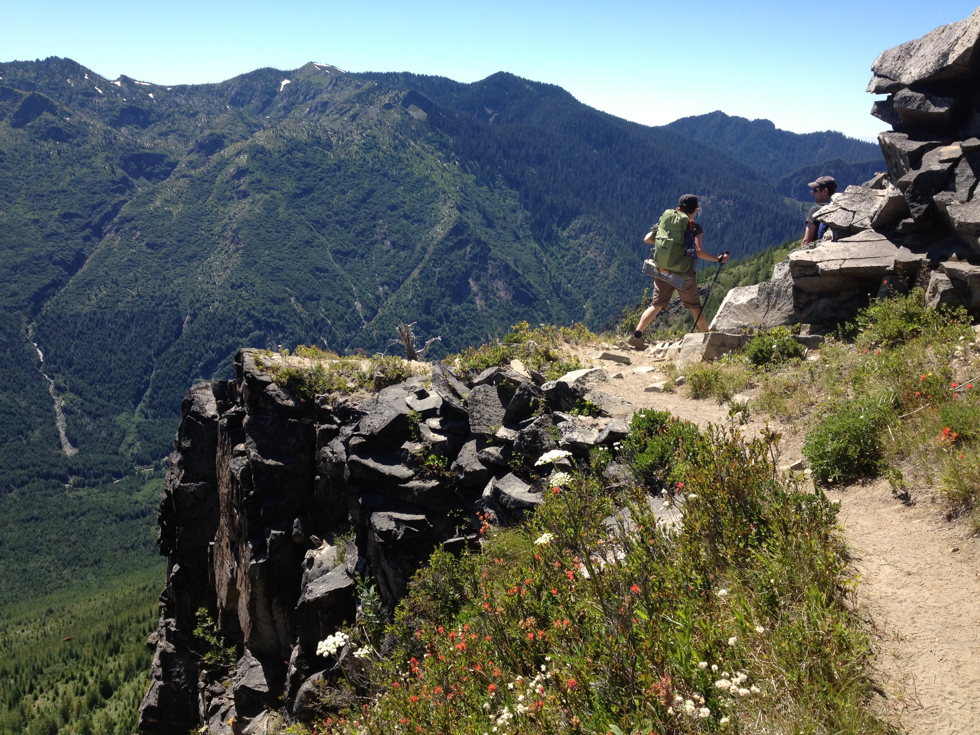
 Once at the summit on Goat Mountain Ridge, we were all in awe. The panoramic views of Mt. Margaret and her valley, Mt. Hood, Mt. St. Helens, Mt. Adams, and Mt. Rainier were stunning. We spotted the heart-shaped lake where we’d begun in the distance and enjoyed the views for a few moments. All of the mountains were slightly snow-covered and visible all at once along either side of the ridge, making it one of the greatest points I’ve ever hiked in the Pacific Northwest.
Not only were the mountain views incredible, but the number of flowers and wide variety of trees were amazing, too. There were Queen Anne’s Lace, penstemon, paintbrush, lousewort, and wild rose, as well as yarrow, lupine, wild strawberry, larkspur, columbine, and daisy. One of the reasons this area is so amazing is its geological and botanical diversity which developed because of Mt. St. Helens’s recent and historic blasts. Pumice stone, ash, and hot gases helped to shape this area and have created a unique home for hundreds of species of flower, tree, and animal.
 The trail skirts along the ridge for a bit after the vista, then dips down into the saddle or backside where we were viciously attacked by mosquitoes. I was glad I had some spray at the ready for us to soak ourselves with, but even stopping to spray called them out of hiding for a bite. Hoping the biting bugs weren’t going to be bothering us all night, we continued down the back of the ridge.
After 8 miles of hiking, we found ourselves at our camp alongside little Vanson Lake. Warm from the activity and the sun still pretty high in the sky, we all went for a quick dip in the icy water. It was refreshing, but I didn’t want to stay in there for too long. I still needed to dry my clothes for the next day’s hike. That night, I listened to the song of the toads and gently swung in my hammock bed. I have really taken a liking to sleeping in the hammock whenever possible, and that night was one of the most pleasant yet.
Day 1 Hiking Stats:
Hiked 8 miles in, 3:08 moving time, and elevation gain 2,715 feet.
 The journey back to the car on the second day was perfect. No descent caused serious discomfort on the knees, but it was quite a drop into the valley below. The trail followed the river the entire way and gave us plenty of opportunities to hop in to cool our toes. We saw a few people the second day: two on horses, and four on mountain bikes. We also ate a healthy helping of salmonberries and huckleberries along the trail. Some were enormous, and there were so many we wondered why others hadn’t eaten them.

The best part about this day for me was the incredible old growth forest. Giant trees surrounded us on all sides throughout the day and played a huge role in the beauty of the shady trail here. Many fallen trees displayed signs of ancient climate changes in the cut rings visible from clearing the trail and we all wondered if the 30-year-old St. Helens eruption had left a visible mark in the rings. Without an expert along with us, we could only speculate.
 This day was full of landscape changes just as it had been the day before. The changes ranged from jagged rocks to meadows of flowers, from the giant fir trees to forests of alder. Waterfalls sank into the horizon to our right and occasionally we would spy where we’d been the day before high on the ridge to our left. The trail became dusty and steep just before we made our way to the parking lot where we’d started and after 11 miles I was wishing I’d saved some energy for the last climb. We now had only the 2-hour and 45-minute journey back to Portland.
Day 2 Hiking Stats:
Hiked 11.36 miles, 3:42 moving time, and elevation gain of 1,582 feet.
Directions from I-5:
Take the Woodland Exit 21, travel 23.5 miles east on Highway 503 to a junction. Continue straight on Hwy 503 Spur and proceed 24.2 miles to a junction immediately past the Pine Creek Information Station. Continue straight, now on Forest Road 25, drive 25.6 miles to a major intersection. Turn left on Road 99, following signs to Windy Ridge, go 9.2 miles, and then turn right on single-lane paved road 26. In recent years this road has often been closed due to washouts. Take your time, the bumps can be deep. Continue 4.6 miles to a junction about 100 yards after the turnoff for the Ryan Lake Interpretive Site. Turn left on gravel Road 2612 and drive .4 miles to a large gravel trailhead parking lot on the right.
Maps:

Hi Clarissa, the guide book I show for this hike was One Night Wilderness: Portland
Can you share the name of the guide book with the map at the end of this post? Thanks!